
ArcInfo 8: A New Vision for GIS
An ESRI White
Paper • June 1999
ArcInfo 8: A New Vision for GIS
An ESRI White
Paper • June 1999
Copyright ©
1999 Environmental Systems Research Institute, Inc.
All rights
reserved.
Printed in
the United States of America.
The
information contained in this document is the exclusive property of
Environmental Systems Research Institute, Inc.
This work is protected under United States copyright law and other
international copyright treaties and conventions. No part of this work may be reproduced or transmitted in any form
or by any means, electronic or mechanical, including photocopying and
recording, or by any information storage or retrieval system, except as
expressly permitted in writing by Environmental Systems Research Institute,
Inc. All requests should be sent to
Attention: Contracts Manager, Environmental Systems Research Institute, Inc.,
380 New York Street, Redlands, CA 92373-8100, USA.
The
information contained in this document is subject to change without notice.
U.S. Government
Restricted/Limited Rights
Any
software, documentation, and/or data delivered hereunder is subject to the
terms of the License Agreement. In no
event shall the Government acquire greater than RESTRICTED/LIMITED RIGHTS. At a minimum, use, duplication, or
disclosure by the Government is subject to restrictions as set forth in FAR §52.227-14 Alternates I, II, and III (JUN 1987); FAR §52.227-19 (JUN 1987) and/or FAR §12.211/12.212 (Commercial Technical Data/Computer
Software); and DFARS §252.227-7015 (NOV 1995)
(Technical Data) and/or DFARS §227.7202
(Computer Software), as applicable. Contractor/Manufacturer
is Environmental Systems Research Institute, Inc., 380 New York Street,
Redlands, CA 92373-8100, USA.
ARC/INFO, ArcCAD,
ArcView, BusinessMAP, ESRI,
MapObjects, and PC ARC/INFO are trademarks of Environmental Systems Research
Institute, Inc., registered in the United States and certain other countries;
registration is pending in the European Community. 3D Analyst, ADF, ARC COGO, the ARC COGO logo, ARC GRID, the ARC
GRID logo, AML, ARC NETWORK, the ARC NETWORK logo, ARC News, ARC TIN, the ARC TIN logo, the ARC/INFO logo, ARC/INFO
LIBRARIAN, ARC/INFO—Professional GIS, ARC/INFO—The World's GIS, ArcAtlas, the
ArcAtlas logo, ArcBrowser, the ArcCAD logo, the ArcCAD WorkBench logo, ArcCensus,
ArcCity, the ArcData logo, the ArcData Online logo, ArcDoc, ARCEDIT, the
ARCEDIT logo, ArcExplorer, the ArcExplorer logo, ArcExpress, the ArcExpress
logo, ArcFM, the ArcFM logo, the ArcFM Viewer logo, ArcIMS, the ArcIMS logo,
ArcInfo, ArcLogistics, the ArcLogistics Route logo, ARCPLOT, the ARCPLOT logo,
ArcPress, the ArcPress logo, the ArcPress for ArcView logo, ArcScan, the
ArcScan logo, ArcScene, the ArcScene logo, ArcSchool, ArcSDE, the ArcSDE logo,
ArcSdl, ARCSHELL, ArcStorm, the ArcStorm logo, ArcTools, the ArcTools logo,
ArcUSA, the ArcUSA logo, ArcUser, the
ArcView GIS logo, the ArcView 3D Analyst logo, the ArcView Business Analyst
logo, the ArcView Data Publisher logo, the ArcView Image Analysis logo, the
ArcView Internet Map Server logo, the ArcView Network Analyst logo, the ArcView
Spatial Analyst logo, the ArcView StreetMap logo, the ArcView StreetMap 2000
logo, the ArcView Tracking Analyst logo, ArcVoyager, ArcWorld, the ArcWorld
logo, Atlas GIS, the Atlas GIS logo, AtlasWare, Avenue, the Avenue logo, the BusinessMAP logo, DAK, the DAK logo,
DATABASE INTEGRATOR, DBI Kit, the Digital Chart of the World logo, the ESRI
globe logo, the ESRI corporate logo, ESRI—Team GIS, ESRI—The GIS People,
FormEdit, Geographic Design System, Geography Matters, GIS by ESRI, GIS for
Everyone, GISData Server, IMAGE INTEGRATOR, InsiteMAP,
MapCafé, the MapCafé logo, the MapObjects logo, the MapObjects Internet Map
Server logo, NetEngine, the NetEngine logo, the PC ARC/INFO logo,
PC ARCEDIT, PC ARCPLOT, PC ARCSHELL, PC DATA CONVERSION, PC NETWORK,
PC OVERLAY, PC STARTER KIT, PC TABLES, the Production Line Tool Set logo,
Spatial Database Engine, SDE, the SDE logo, the SDE CAD Client logo, SML,
StreetMap, TABLES, The World's Leading Desktop GIS, ViewMaker, Water Writes, and Your Personal
Geographic Information System are trademarks and ArcData, ARCMAIL, ArcOpen,
ArcQuest, ArcWatch, ArcWeb,
Rent-a-Tech, @esri.com, and www.esri.com are
service marks of Environmental Systems Research Institute, Inc.
The names of other companies and products herein are
trademarks or registered trademarks of their respective trademark owners.
ArcInfo
8: A New Vision for GIS
An
ESRI White Paper
Contents Page
Abstract 1
Introduction 1
ArcInfo
Workstation—The Best Gets Better 2
ArcInfo
Desktop—New Views on GIS 2
Catalogs, Tools, and Maps 2
ArcCatalog 3
ArcToolbox 4
ArcMap 4
Wide Open, No Limits
Customization 6
Supervisory Control and Data
Acquisition 7
Object-Oriented Data Model 7
Data Management 8
New System Architecture 9
ArcInfo: A System of Parts 9
Conclusion 9
ArcInfo
8: A New Vision for GIS
|
Abstract |
ArcInfo™ is the world-leading software for geographic information system (GIS) professionals. Recent advances in computer technology, both in hardware and software, have created new and exciting possibilities for GIS—and for growing ArcInfo to meet them. Reengineered and redesigned from first principles, ArcInfo 8 is an easy-to-use, fast, and |
modern GIS. The strategy of version 8 is simple: introduce a new suite of applications, a revolutionary data model, and a completely open architecture alongside the well-known existing ArcInfo architecture and applications. All of these can be implemented on a single desktop machine or a networked departmental or enterprise system.
|
Introduction |
ArcInfo 8 is a professional GIS designed to meet all your geographic analysis, display, management, and processing needs. It contains all the tools necessary to build and |
maintain geodatabases; to display, query, manipulate, and analyze geographic data; and to create charts, reports, and maps. The same technology can be deployed as a stand-alone lightweight viewer or a collection of networked, fully functional, sophisticated editing and analysis stations.
|
Workstation |
Desktop |
|
ARC |
ArcCatalog |
|
ARCEDIT |
ArcMap |
|
ARCPLOT |
ArcToolbox |
|
AML |
Object Editor |
|
ODE |
ArcServer |
|
ARC/INFO LIBRARIAN |
VBA |
|
INFO |
Personal SDE |
|
ARC COGO |
Charting |
|
ARC GRID |
Reporting |
|
ARC NETWORK |
|
|
ArcScan |
|
|
ArcSDE |
|
|
ArcStorm |
|
|
ARC TIN |
|
The main parts of ArcInfo 8
ArcInfo 8 represents both the next release of a highly successful world-leading GIS and the first release of the next generation of GIS. A key feature of ArcInfo 8 is the way existing ArcInfo applications and technology are a part of the system. For convenience we refer to the existing applications and technology as ArcInfo Workstation and the new applications and technology as ArcInfo Desktop.
|
ArcInfo Workstation—The Best Gets Better |
ArcInfo 8 is completely compatible with existing ArcInfo 7 applications and data. The familiar ARC, ARCEDIT™, and ARCPLOT™ applications; the ARC Macro Language (AML™) and Open Development Environment (ODE) customization capabilities; and all |
the extensions (except ArcExpress™ software) are present. The workstation ArcInfo applications have been improved and blend into the new system. ArcInfo Workstation will be the cornerstone of the GIS work for many users for some time to come, and it is central in the role of ArcInfo 8 software's power and scalability.
ArcInfo Workstation has been extended and enhanced in many ways: there is a Java ODE, improved Spatial Data Transfer Standard converter, shapefile 2 converter, updated TIGER converter, new generalization commands (e.g., for automated creation of street centerlines), new industry-style sets, improvements to the defined layers interface (e.g., image support), new ARC COGO™ tools and commands, improvements to ARCEDIT, support for ARC TIN™ data loading and extraction from Spatial Database Engine™ (SDE™), and license management enhancements.
A key new feature that spans ArcInfo Workstation and ArcInfo Desktop is the ability to configure UNIX or Windows NT ArcInfo Workstation as the server for processing jobs compiled on a Windows NT ArcInfo Desktop client. Additionally, ArcInfo Workstation has been extended to read and query the new data types introduced in ArcSDE™ 8 software and ArcInfo Desktop.
ArcInfo Workstation still has the broadest platform base of any GIS software. Support for many UNIX platforms, including DEC Alpha NT, makes it the choice for focused, computation-intensive jobs. It also runs on the Microsoft Windows NT operating system.
|
ArcInfo Desktop—New Views on GIS |
GIS users need new ways of working with GIS. The problems GIS users face are more complex than ever before and require vast collections of data and methods to solve them. Yet, too much information is often the problem. Users need tools that will help them cut |
to the essence of what they need to know and what they need to do.
The central design concept of the new technology is to make GIS simple—make it easy to use. Not just easy for simple things but easy to use for complex things as well. Three new applications (programs) do just that. Each of these applications approaches GIS from a different perspective; each tailored to help a user accomplish related tasks quickly without overloading them with detail. The secret to simplicity is the interface. Even though ArcInfo functionality is massive, the user is presented with what they need, when they need it. These new applications are collectively referred to as ArcInfo Desktop.
|
Catalogs, Tools, and Maps |
The user experience is simplified through three elemental concepts: catalogs, tools, and maps. Each of these is the focus of one of the applications in the suite. While the three |
applications are discussed separately here, it should be emphasized that they interoperate and form an integrated GIS desktop.
|
ArcCatalog |
ArcCatalog is entirely different from any previous GIS application. It resembles the Windows Explorer but can see down into databases and files. It has a multimode view pane for quickly discovering geographic data and metadata and hosts all data management tasks with easy-to-use interfaces and wizards. It provides the data-centric |
perspective of GIS. ArcCatalog is needed because the number, size, and complexity of GIS databases have grown to a confusion of information. Users need to be able to understand what data is available to help solve a problem, quickly grasp its limits, and move the right data into a work flow.
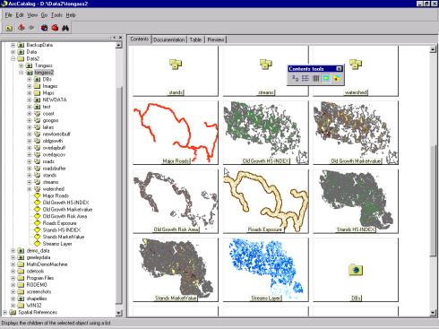
ArcCatalog is a data organizer and manager. The left-hand "tree" is a live hierarchical view of all data on a user's machine and network. The right-hand pane is a preview of the data layers and maps in a particular folder (directory).
ArcCatalog helps GIS database administrators maintain spatial and tabular GIS data for use by others in their organization. With ArcCatalog, GIS professionals performing spatial analysis can more easily fulfill their responsibility for metadata maintenance tasks following actual analysis and data conversion. Application users and entry-level analysts can employ ArcCatalog to discover the content and properties of GIS data.
|
ArcToolbox |
ArcToolbox is a new interface to the geoprocessing power of ArcInfo. Over 120 tools are organized in a tree hierarchy that is easily searchable, with wizards to support complex tasks such as projection and overlay. With ArcToolbox, geoprocessing is easier |
to comprehend and carry out. ArcToolbox brings high-level geoprocessing within the grasp of everyone. The network is the platform, so users can compose massive geoprocessing jobs, submit them for execution on a server, and keep working. GIS beginners and seasoned professionals will benefit from the modern user interface and extensive online help and documentation in ArcToolbox.
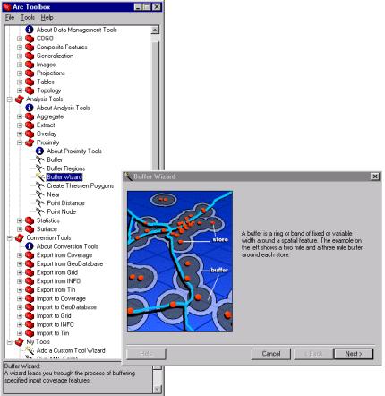
ArcToolbox makes geoprocessing accessible. The left-hand window shows the hierarchy of
ArcToolbox tools. The right-hand window
is a single panel from the buffer tool wizard.
|
ArcMap |
Many users will see ArcMap as
the central application where they will spend most of their time. It is an easy-to-use, fully menu-driven
application for working with any type of map data. Existing ArcInfo users will think of it as the power and flexibility
of ARCEDIT and ARCPLOT in one modern application, and more.
It is a completely |
integrated map-centric
application for creating and editing spatial databases, displaying and querying
geographic data, performing complex analysis, generating quality reports and
charts, and making high-quality maps.
ArcMap expands on concepts and interfaces first introduced in the
popular ArcView® GIS software, but with ArcInfo
functionality.
ArcMap—a fully
integrated editing and mapping application.
ArcMap extends even further ESRI's popular direct data read capability that allows popular data sets to be used on the fly without translation or use of an intermediate format. It supports ArcInfo coverages, ESRI® shapefiles, SDE layers, map library layers, ArcStorm™ layers, DXF/DWG files, and many more. ArcMap additionally supports on-the-fly projection.
ArcMap software's Windows-compliant graphical user interface (GUI) makes common tasks, such as geocoding and map navigation, extremely intuitive. The user can perform thematic and topographic mapping or map-based query and analysis, view data as a table, create a chart or report, and perform map-centric geoprocessing all within the same user-friendly ArcMap environment.
ArcMap Object Editor. ArcMap includes a fully integrated Object Editor capable of multiuser geographic and attribute data entry and update. The Object Editor is implemented in such a way as to ensure a simple, quick, and natural transition from viewing geography to editing geography. The Object Editor can work with coverages, shapefiles, and all-relational geodatabases stored in ArcSDE. The new computer-aided design (CAD) tools, interactive editing, and work flow approach make it easy to create and maintain geographic databases.
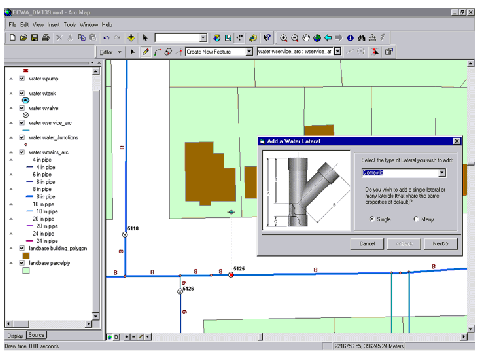
ArcMap Object
Editor—intelligent editing of geographic data.
|
Wide Open, No Limits Customization |
ArcInfo 8 software's new suite of end user applications take advantage of the Microsoft Windows platforms, with all of the power of user-friendly standards. ArcInfo 8 is Windows 2000 Logo compliant—this means standard Windows look and feel, standard install and uninstall practices, and a standard help system. From a user's perspective this |
is manifested in, for example, full drag and drop capability between applications, so a user can find data in ArcCatalog, drag it to ArcToolbox, and drop it on the tool they want to use. Users can also embed tables, charts, reports, and maps into other Windows-compliant software, or embed other Object Linking and Embedding (OLE) components in a map.
All ESRI data formats can be used with this new software. There is no need to convert data from existing databases, coverages, or shapefiles into the new data models to use these applications and increase productivity.
ArcInfo 8 provides a level of customization that goes far beyond any other GIS software. It is completely customizable from data objects to toolbars. There are three levels of customization: drag and drop interface customization, Visual Basic for Applications (VBA) for most application programming needs, and component–object programming for advanced development.
Nonprogrammers can easily customize the application interfaces. Elements on toolbars and menus may be repositioned or removed, and new elements may be dragged from the customization dialog to any position on a toolbar or menu. Toolbars may be positioned freely or docked to various areas of the application frame horizontally or vertically, and with few exceptions, any toolbar item can also be moved onto a menu.
Most programming needs are met with Microsoft VBA, which is embedded in ArcMap and ArcCatalog. VBA is equivalent to Microsoft Visual Basic (VB), the industry standard in Windows programming. VBA has an Integrated Development Environment that is easy to use, has access to a rich set of interface programming tools, provides an object browser, and has its own program editor.
Advanced development can be accomplished with any Component Object Model (COM)-compliant programming environment. Nearly all of the system is open to customization at this level. Users can extend the data and application framework models, build behavior into data objects, integrate their own subsystems and analytical engines, and even create their own proprietary data formats.
|
Supervisory Control and Data Acquisition |
In its early years, GIS was heralded for its ability to integrate diverse data and sciences. Now it must be integrated into other technologies and sciences as well. The new |
component architecture allows developers to embed ArcInfo components into their own applications. The convergence of GIS technology with technologies such as Supervisory Control and Data Acquisition (SCADA), global positioning systems, financial, work management, and simulation will create systems that extend from the field across the World Wide Web and up to the enterprise.
|
Object-Oriented Data Model |
Prior to version 8, ArcInfo was based on the highly successful georelational data model. This geometry-centered model focused on point, line, and polygon geometry types, storing geometry and topology in binary files and associated attributes in a database |
management system. Both ArcInfo Workstation and ArcInfo Desktop continue to support fully the georelational model.
Version 8 introduces a new object-oriented data model for the creation of intelligent geodatabases that combine the properties of objects with their behavior. ArcInfo implements objects in a modern standard way: each object is defined as a separate component or building block. This allows users to create their own object-oriented models that extend the base model. Object–component data models closely resemble the user's view and classification of the things they are studying. Because of this, the data models are intuitive and simple to use: the software will deal with user-oriented concepts like land parcels and easements, transformers and fuses, not system-oriented concepts like points, lines, and polygons. GIS will be more extendable by users and third party developers: new components can easily be plugged into the system and anyone proficient in modern programming techniques will be able to create first class objects. Standards mean better use of well established tools such as programming languages, Computer-Aided Software Engineering (CASE) tools, and databases; they also mean openness and interoperability. The ArcInfo Desktop applications have been designed specifically to work with this new data model.
ArcInfo 8 uses an object–component data model that will in several respects revolutionize GIS. ArcInfo facilitates tasks such as
n Editing a heterogeneous set of features such as simultaneously editing
points and lines
n Modeling
complex network features such as devices on a network that have internal
circuitry represented by discrete features
n Representing
a feature's geometry with parametric curves such as circular arcs and Bezier
curves
n
Managing a versioned database that
supports work order management and many simultaneous edits
n
Adding extensions such as a charting
system or report writer at run time
n
Representing features in multiple ways
in the core software (e.g., the generic draw methods of city objects could
represent them as red points at 1;500,000 scale, and orange polygons at
1:50,000)
|
Data Management |
ArcInfo 8 was
designed from the outset to work natively with multiple data formats: both file and database resident
geodatabases. These include file
formats like coverages, shapefiles, CAD files, and many image formats as well
as two kinds of ArcSDE. Every |
copy of ArcInfo includes an embedded version
of ArcSDE. This is a
"personal" version of ArcSDE that stores data in Microsoft Access
(strictly speaking it is the Jet Engine that underlies Access). Although this is a full version of the
ArcSDE technology, the term Personal SDE has been adopted because it requires
almost zero administration (indeed many users will never even know that ArcSDE
is installed on the system) and
because it only allows single-user editing/update (multiuser read access is
fully supported).
For users who want to use true multiuser editing, store their data in other relational databases (e.g., DB2, Informix, Oracle, SQL Server, or Sybase), or operate in a client/server configuration, ArcSDE 8 is an option.
In many respects the new version of ArcSDE is as revolutionary as ArcInfo 8. Key new features include direct editing of a versioned managed geodatabase in a long transaction environment. An ArcInfo 8 user can invoke the editor within the main display window of ArcMap and start editing. In the background, unknown to many users, they will connect to an ArcSDE database, start a long transaction on a versioned database, and begin direct editing of the database features. When all the required edits have been performed the transaction can be committed. If someone else had been editing the same features at the same time and caused a conflict, the user is given options to discard their edits, override conflicts in the database, reconcile any conflicts, or make a new database version that could be reconciled later.
ArcSDE 8 also supports two new data types: images and addresses. The new data structures and tools together provide users with strong data management, access, and manipulation tools for these and existing tools.
|
New System Architecture |
ArcInfo 8 software's architecture is based on cutting-edge software engineering and an open strategy. This is a major improvement in the way ArcInfo works with other modern software in the increasingly networked and integrated world. |
The open nature of this architecture was achieved through the use of object-oriented design and programming. ArcInfo 8 is based on the Component Object Model, a de facto standard for software development today. It allows integration at a very low level in the software. Examples of this are the new charting and reporting capabilities introduced in ArcInfo 8, which were built on reusable commercial components developed independently by another company. Object-oriented methods were followed not just in the software but also in the data model. The use of COM and industry-standard languages and programming environments that support COM leverages non-GIS programmers in an organization.
|
ArcInfo: A System of Parts |
ArcInfo has always been a system, not a single application interface. Different parts of the system can be pulled together to analyze problems or build lasting productive |
solutions tailored to the specific needs of a site or project. ArcInfo software's support for many platforms continues to set it apart from competing single platform systems. Now the network is the platform, and the ArcInfo system can be distributed across the network with a proper pairing of function with network node (client/server). For instance, high- performance UNIX machines can host data and geoprocessing services (ArcSDE and ArcServer) and use Windows Excel as end user interactive desktop seats. Of course, ArcInfo 8 can run entirely on a single platform as well.
|
Conclusion |
ArcInfo 8 represents a new vision for GIS in the new millennium. It is a modern, easy-to-use, and fast GIS solution with several uniquely distinguishing characteristics. |
n Three new GIS applications (ArcCatalog, ArcMap, and ArcToolbox) that make users immediately productive. These combine to create a complete desktop for GIS data entry, manipulation, analysis, and display.
n The wide range of GIS functions, unmatched by any GIS product, means that whatever the project, ArcInfo can solve the problem.
n The powerful object-oriented object model is able to represent the richness of the real world making ArcInfo more natural to use and understand.
n First-generation component GIS, such as ArcInfo 7, had a COM wrapper around legacy code; ArcInfo 8, on the other hand, was designed for COM and has several hundred component classes and several thousand methods. This fine-grained object-component software architecture makes the software inherently scalable and customizable allowing developers to create highly focused applications.
n ArcInfo 8 is able to work
directly with many data types without the need for costly translation via an
intermediate file format. It is unique
in being able to store and directly edit all data in a versioned commercial
relational database management system.
This allows GIS users to benefit from the work of DBMS vendors (data
integrity, reliability, backup/restore, etc.) and to share data easily with
others in the enterprise.
n ArcInfo 8 runs on both Windows
and UNIX. Windows is the best platform
today for high-performance, interactive desktop applications, while on the
serverside both Windows and UNIX are good choices. This multiplatform strategy means users can continue to use
existing hardware and to take advantage of the special characteristics of each
new hardware platform.
n ArcInfo 8 was designed from
the outset with end users and developers in mind. While the software works superbly well out of the box, it can
also be totally customized. Even
nonprogrammers can customize the software using the menu-driven user interface. Serious commercial developers will also be
satisfied with the fine-grained component architecture, the capability to use
any COM-compliant language (e.g., Visual C++, Delphi, Visual J++, or Visual
Basic), and the compatibility with industry-standard CASE tools.
n Last, but not least, the GIS
of today needs to work with many other information systems (databases, word
processors, statistical analysis systems, data collection devices, etc.). One way to achieve interoperability is
through the use of industry standards.
ArcInfo is built on industry standards.
From the Windows GUI to the OLE/COM component architecture to the use of
SQL for data access and TCP/IP for networking, ArcInfo 8 is open,
interoperable, and extendable.